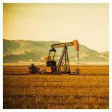
ONLINE MINERAL INTERESTS AUCTION
Bidding begins closing Thursday, December 18th at 7:00PM
OVER 24,500 ACRES MINERAL INTEREST ACROSS 14 COUNTIES
For more information or to access the data room, please call Jordan Kiger, Salesperson at 724-998-5810
INCLUDING MONONGALIA, TAYLOR, WETZEL, MARION, PRESTON, BARBOUR, PRESTON, NICHOLAS, GREENBRIER, PENDLETON, BRAXTON, GRANT, RANDOLPH COUNTIES
BIDDING METHOD – PER-ACRE BASIS – PLEASE READ CAREFULLY
The mineral, oil, gas, coal, or other subsurface rights being conveyed herein are sold on a per-acre basis, the acreage amount advertised and represented prior to the auction is understood to be based on the best available information but is not guaranteed. Should any subsequent title search, or other verification determine that the actual acreage differs from the advertised or represented acreage, the Purchaser agrees that the total purchase price shall be adjusted solely on the basis of the final verified acreage multiplied by the per-acre purchase price established at auction. Any variance in acreage shall not entitle the Purchaser to rescind this Agreement, seek damages, or otherwise avoid performance hereunder. Purchaser acknowledges that this provision shall survive closing and shall be binding upon the parties and their heirs, successors, and assigns.
Purchase Price will be calculated as:
Actual Acreage X Per Acre Bid + Buyer's Premium = Total Contract Price
For Example 235 +/- Acres x $750/per acre = $176,250 High Bid
$176,250 + 10% Buyer Premium = Total Contract Price $193,875
120 days will be given to close, allowing enough time for title examinations following the auction.
SUBJECT #10: MONONGALIA COUNTY, BATELLE DISTRICT, 67 +/- ACRES
Battelle District, Map 9999, Parcel 0010.1420
Legal Description: 67.159 AC CO&G MIN (UNDER 13-35)
SUBJECT #11: MARION COUNTY, PAW PAW DISTRICT 126 +/- ACRES
Paw Paw District, Map 9999, Parcel 0161.0030
Legal Description: 112.86 AC O&G ROBINSON RUN
SUBJECT #12: WETZEL COUNTY, GRANT DISTRICT 162 +/- ACRES
Grant District, Map 9999, Parcel 0003.3930 Containing 1 +/- Acres
Legal Description: 1 AC LEASED OG EQT WEEKLEY 1H NRA 20142573
Grant District, Map 9999, Parcel 0003.4210 Containing 1 +/- Acres
Legal Description: 1 AC LEASED OG EQT WEEKLEY 2H NRA 20142689
Subsurface Interest Underlying Grant District, Map 22, Parcel 43 Containing 160 +/- Acres
Subsurface Interest Underlying Grant District, Map 22, Parcel 42 Containing .16 +/- Acres
SUBJECT #13: TAYLOR COUNTY, FETTERMAN DISTRICT 229 +/- ACRES
Fetterman District, Map 9999, Parcel 2010.1290 Containing 77.60 +/- Acres
Legal Description: THREE FORK 77.60 AC O & G UNDER 5/33 & 5/40
Subsurface Interest Underlying
Fetterman District, Map 5, Parcel 33 Containing 27.60 +/- Acres
Fetterman District, Map 5, Parcel 40 Containing 50 +/- Acres
Fetterman District, Map 17, Parcel 42.1 Containing 2.01 +/- Acres
Fetterman District Map 22, Parcel 13 Containing 34.7 +/- Acres
Fetterman District, Map 23, Parcel 13 Containing 2.50 +/- Acres
Fetterman District, Map 23, Parcel 14 Containing 35.44 +/-Acres
SUBJECT #14: BARBOUR COUNTY, GLADE DISTRICT 496 +/- ACRES
Conveying any and all existing mineral/subsurface interest, including but not limited to coal, oil, and gas underlying these tracts
Glade District, Map 4, Parcel 12 Containing 185 +/- Acres
Glade District, Map 4, Parcel 12.1 Containing 45 +/- Acres
Glade District, Map 4, Parcel 14 Containing 70 +/- Acres
Glade District 5, Map 9999, Parcel 0050.4271 Containing 196 +/- Acres
SUBJECT #15: BARBOUR COUNTY, COVE DISTRICT 667 +/- ACRES
Conveying any and all existing mineral/subsurface interest, including but not limited to coal, oil, and gas
Cove District, Map 9999, Parcel 0317.0001
Legal Description: 667 ACS OG & UNS MINS LAUREL HILL
SUBJECT #16: BARBOUR COUNTY, COVE DISTRICT 285 +/- ACRES
Conveying any and all existing mineral/subsurface interest, including but not limited to coal, oil, and gas underlying these tracts
Cove District, Map 9, Parcel 1 Containing 46 +/- Acres
Cove District, Map 10, Parcel 7 Containing 90 +/- Acres
Cove District, Map 10, Parcel 15 Containing 101.83 +/- Acres
Cove District, Map 10, Parcel 20 Containing 47.10 +/- Acres
SUBJECT #17: PRESTON COUNTY, RENO DISTRICT 4,212 +/- ACRES
Conveying any and all existing mineral/subsurface interest, including but not limited to coal, oil, and gas
Reno District, Map 9999, Parcel 0921.5887 Containing 5.950 +/- Acres
Reno District, Map 9999, Parcel 0921.5888 Containing 52.510 +/- Acres
Reno District, Map 9999, Parcel 0921.5889 Containing 12 +/- Acres
Reno District, Map 9999, Parcel 0921.5890 Containing 10.000 +/- Acres
Reno District, Map 9999, Parcel 0921.5891 Containing 93.50 +/- Acres
Reno District, Map 9999, Parcel 0921.5892 Containing 14 +/- Acres
Reno District, Map 9999, Parcel 0608.4907 Containing 612.71 +/- Acres
Reno District, Map 9999, Parcel 0921.5893 Containing 69.45 +/- Acres
Reno District, Map 9999, Parcel 0921.5896 Containing 88.00 +/- Acres
Reno District, Map 9999, Parcel 0921.5897 Containing 200 +/- Acres
Reno District, Map 9999, Parcel 0921.5898 Containing 12.41 +/- Acres
Reno District, Map 9999, Parcel 0921.5902 Containing 76.75 +/- Acres
Reno District, Map 9999, Parcel 0921.5950.3001 Containing 100 +/- Acres (3/4 Interest)
Reno District, Map 9999, Parcel 0921.5951.3001 Containing 1 +/- Acres (3/4 Interest)
Reno District, Map 9999, Parcel 0624.0249.3001 Containing 8.75 +/- Acres (3/4 Interest)
Reno District, Map 9999, Parcel 0921.5952.3001 Containing 58.375 +/- Acres (3/4 Interest)
Reno District, Map 9999, Parcel 0921.5953.3001 Containing 52.375 +/- Acres (3/4 Interest)
Reno District, Map 9999, Parcel 0921.5954.3001 Containing 65 +/- Acres (3/4 Interest)
Reno District, Map 9999, Parcel 0921.5955.3001 Containing 32.50 +/- Acres (3/4 Interest)
Reno District, Map 9999, Parcel 0921.5900 Containing 86 +/- Acres
Reno District, Map 9999, Parcel 0921.5901 Containing 85 +/- Acres
Reno District, Map 9999, Parcel 0921.5903 Containing 9.09 +/- Acres
Reno District, Map 9999, Parcel 0921.5904 Containing 84.38 +/- Acres
Reno District, Map 9999, Parcel 0921.5905 Containing 30.60 +/- Acres
Reno District, Map 9999, Parcel 0921.5907 Containing 53.75 +/- Acres
Reno District, Map 9999, Parcel 0921.5908 Containing 75 +/- Acres
Reno District, Map 9999, Parcel 0624.1621 Containing 30 +/- Acres
Reno District, Map 9999, Parcel 0624.1630 Containing 60 +/- Acres
Reno District, Map 9999, Parcel 0921.5912 Containing 20 +/- Acres
Reno District, Map 9999, Parcel 0921.5913 Containing 810 +/- Acres
Reno District, Map 9999, Parcel 0608.2124 Containing 126 +/- Acres (1/8 interest)
Reno District, Map 9999, Parcel 0921.6013 Containing 377.170 +/- Acres
Subsurface Interest Underlying
Reno District, Map 17, Parcel 32.3 Containing 18.1 +/- Acres
Reno District, Map 29, Parcel 13 Containing 129.575 +/- Acres
Reno District, Map 35 Parcel 4 Containing 58.000 +/- Acres
Reno District, Map 35, Parcel 10 Containing 310.5 +/- Acres
Reno District, Map 36, Parcel 2.1 Containing 50 +/- Acres
Subject #18: PRESTON COUNTY, UNION DISTRICT 1,546 +/- ACRES
Conveying any and all existing mineral/subsurface interest, including but not limited to coal, oil, and gas
Union District, Map 9999, Parcel 0921.5886 Containing 155.637 +/- Acres
Union District, Map 9999, Parcel 0921.5885 Containing 240 +/- Acres
Union District, Map 9999, Parcel 0921.6018 Containing 363.88 +/- Acres
Union District, Map 9999, Parcel 0921.5881 Containing 435.30 +/- Acres
Union District, Map 9999, Parcel 0921.5882 Containing 79.66 +/- Acres
Union District, Map 9999, Parcel 0921.5883 Containing 34 +/- Acres
Union District, Map 9999, Parcel 0921.5884 Containing 27.89 +/- Acres
Union District, Map 9999, Parcel 0921.5879 Containing 90 +/- Acres
Union District, Map 9999, Parcel 0610.8883 Containing 70.00 +/- Acres
Union District, Map 9999, Parcel 0610.4235 Containing 50.00 +/- Acres
SUBJECT #19: PRESTON COUNTY PLEASANT DISTRICT 1,629 +/- ACRES
Conveying any and all existing mineral/subsurface interest, including but not limited to coal, oil, and gas
Pleasant District, Map 9999, Parcel 0921.5915 Containing 50.59 +/- Acres
Pleasant District, Map 9999, Parcel 0921.5916 Containing 72 +/- Acres
Pleasant District, Map 9999, Parcel 0921.8347 Containing 5 +/- Acres
Pleasant District, Map 9999, Parcel 0921.5917 Containing 32.75 +/- Acres
Pleasant District, Map 9999, Parcel 0921.5918 Containing 27.063 +/- Acres
Pleasant District, Map 9999, Parcel 0921.5919 Containing 19.245 +/- Acres
Pleasant District, Map 9999, Parcel 0921.5920 Containing 204.39 +/- Acres
Pleasant District, Map 9999, Parcel 0921.5921 Containing 124.60 +/- Acres
Pleasant District, Map 9999, Parcel 0921.5924 Containing 26.71 +/- Acres
Pleasant District, Map 9999, Parcel 0921.5925 Containing 25 +/- Acres
Pleasant District, Map 9999, Parcel 0921.5927 Containing 349 +/- Acres
Pleasant District, Map 9999, Parcel 0921.5926 Containing 175 +/- Acres
Pleasant District, Map 9999, Parcel 0921.5928 Containing 164 +/- Acres
Pleasant District, Map 9999, Parcel 0908.4670 Containing 133.000 +/- Acres
Subsurface Interest Underlying
Pleasant District, Map 7, Parcel 4 Containing 40.000 +/- Acres
Pleasant District, Map 7, Parcel 13 Containing 38.000 +/- Acres
Pleasant District, Map 8, Parcel 1 Containing 127.440 +/- Acres
Pleasant District, Map 8, Parcel 4.1 Containing 15.300 +/- Acres
SUBJECT #20: PRESTON COUNTY, VALLEY DISTRICT 592 +/- ACRES
Conveying any and all existing mineral/subsurface interest, including but not limited to coal, oil, and gas
Valley District, Map 9999, Parcel 0921.5874 Containing 592 +/- Acres
Legal Description: O-G 592 (2 TRS) CHEAT RIVER GIBSON
SUBJECT #21: PRESTON COUNTY, PORTLAND DISTRICT 1,433 +/- ACRES
Conveying any and all existing mineral/subsurface interest, including but not limited to coal, oil, and gas
Portland District, Map 9999, Parcel 0921.5930 Containing 168 +/- Acres
Portland District, Map 9999, Parcel 0921.5931 Containing 996.247 +/- Acres
Portland District, Map 9999, Parcel 0921.5932 Containing 150 +/- Acres
Portland District, Map 9999, Parcel 601.7865 Containing 25 +/- Acres (1/2 Interest)
Portland District, Map 9999, Parcel 602.4795 Containing 72.83 +/- Acres
Portland District, Map 9999, Parcel 613.7110 Containing 21.1 +/- Acres
SUBJECT #22: PRESTON COUNTY, GRANT DISTRICT 1,195 +/- ACRES
Conveying any and all existing mineral/subsurface interest, including but not limited to coal, oil, and gas underlying these tracts
Grant District, Map 22, Parcel 16.6 Containing 3.219 +/- Acres
Grant District, Map 27, Parcel 51 Containing 409.550 +/- Acres
Grant District, Map 28, Parcel 9 Containing 247.000 +/- Acres
Grant District, Map 28, Parcel 8 Containing 450.000 +/- Acres
Grant District, Map 36, Parcel 9 Containing 35.750 +/- Acres
Grant District, Map 36, Parcel 14 Containing 50.300 +/- Acres
SUBJECT #23: PRESTON COUNTY, KINGWOOD DISTRICT 6,578 +/- Acres
Conveying any and all existing mineral/subsurface interest, including but not limited to coal, oil, and gas
Kingwood District, Map 9999, Parcel 0921.5941 Containing 124.88 +/- Acres
Kingwood District, Map 9999, Parcel 0618.5594 Containing 10 +/- Acres
Kingwood District, Map 9999, Parcel 0921.5942 Containing 4.56 +/- Acres
Kingwood District, Map 9999, Parcel 0921.5943 Containing 8 +/- Acres
Kingwood District, Map 9999, Parcel 0921.5944 Containing 96 +/- Acres
Kingwood District, Map 9999, Parcel 0921.5945 Containing 268.78 +/- Acres
Kingwood District, Map 9999, Parcel 0921.5946 Containing 34 +/- Acres
Kingwood District, Map 9999, Parcel 0921.5947 Containing 33.5 +/- Acres
Kingwood District, Map 9999, Parcel 0618.5978 Containing 66.370 +/- Acres
Kingwood District, Map 9999, Parcel 0921.5948 Containing 108.16 +/- Acres
Kingwood District, Map 9999, Parcel 0921.5949 Containing 30 +/- Acres
Kingwood District, Map 9999, Parcel 0921.5960 Containing 94.7 +/- Acres
Kingwood District, Map 9999, Parcel 0921.5961 Containing 30 +/- Acres
Kingwood District, Map 9999, Parcel 0921.5963 Containing 7 +/- Acres (1/4 Interest)
Kingwood District, Map 9999, Parcel 0921.5962 Containing 70.94 +/- Acres
Kingwood District, Map 9999, Parcel 0618.5950 Containing 147.88 +/- Acres
Kingwood District, Map 9999, Parcel 0921.5964 Containing 100.05 +/- Acres
Kingwood District, Map 9999, Parcel 0921.5965 Containing 19.35 +/- Acres
Kingwood District, Map 9999, Parcel 0053.0001 Containing 16 +/- Acres
Kingwood District, Map 9999, Parcel 0921.5967 Containing 15.034 +/- Acres
Kingwood District, Map 9999, Parcel 0921.5968 Containing 45.109 +/- Acres (1/3 Interest)
Kingwood District, Map 9999, Parcel 0921.5970 Containing 52.47 +/- Acres (3/4 Interest)
Kingwood District, Map 9999, Parcel 0921.5969 Containing 128.24 +/- Acres
Kingwood District, Map 9999, Parcel 0921.5971 Containing 102 +/- Acres
Kingwood District, Map 9999, Parcel 0921.5972 Containing 64.08 +/- Acres
Kingwood District, Map 9999, Parcel 0921.5973 Containing 34.85 +/- Acres
Kingwood District, Map 9999, Parcel 0921.5974 Containing 135.685 +/- Acres
Kingwood District, Map 9999, Parcel 0921.5975 Containing 215 +/- Acres
Kingwood District, Map 9999, Parcel 0921.5976 Containing 30 +/- Acres
Kingwood District, Map 9999, Parcel 0921.5977 Containing 723.43 +/- Acres
Kingwood District, Map 9999, Parcel 0921.5978 Containing 84.112 +/- Acres
Kingwood District, Map 9999, Parcel 0601.8766 Containing 1,495 +/- Acres
Kingwood District, Map 9999, Parcel 0618.5683 Containing 180 +/- Acres
Kingwood District, Map 9999, Parcel 0618.5843 Containing 186.51 +/- Acres
Kingwood District, Map 9999, Parcel 0618.5969 Containing 194.26 +/- Acres
Kingwood District, Map 9999, Parcel 0618.6030 Containing 5.34 +/- Acres
Kingwood District, Map 9999, Parcel 0619.4156 Containing 619 +/- Acres
Kingwood District, Map 9999, Parcel 0618.6003 Containing 138.97 +/- Acres
Kingwood District, Map 9999, Parcel 0618.6021 Containing 60 +/- Acres
Kingwood District, Map 9999, Parcel 0618.5497 Containing 17.95 +/- Acres
Subsurface Interest Underlying
Kingwood District, Map 13, Parcel 9 Containing 17.26 +/- Acres
Kingwood District, Map 13, Parcel 3 Containing 33.78 +/- Acres
Kingwood District, Map 13, Parcel 4 Containing 10.43 +/- Acres
Kingwood District, Map 16, Parcel 6 Containing 371.4 +/- Acres
Kingwood District, Map 16, Parcel 95 Containing 185.46 +/- Acres
Kingwood District, Map 23, Parcel 16 Containing 230 +/- Acres
SUBJECT #24: PRESTON COUNTY, LYON AND NEWBURG DISTRICT 2,010 +/- ACRES
Conveying any and all existing mineral/subsurface interest, including but not limited to coal, oil, and gas
Newburg District, Map 9999, Parcel 0921.5873 Containing 42.88 +/- Acres
Lyon District, Map 9999, Parcel 0613.6674 Containing 19.68 +/- Acres
Lyon District, Map 9999, Parcel 0921.5935 Containing 187.43 +/- Acres
Lyon District, Map 9999, Parcel 0921.5936 Containing 25.7 +/- Acres
Lyon District, Map 9999, Parcel 0921.5937 Containing 143 +/- Acres
Lyon District, Map 9999, Parcel 0921.5956 Containing 6 +/- Acres
Lyon District, Map 9999, Parcel 0613.9779 Containing 771.5 +/- Acres
Lyon District, Map 9999, Parcel 0921.5938 Containing 14.91 +/- Acres
Lyon District, Map 9999, Parcel 0613.9868 Containing 570.02 +/- Acres
Subsurface Interests Underlying Lyon District, Map 11, Parcel 1 Containing 65 +/- Acres
Subsurface Interests Underlying Lyon District, Map 15, Parcel 37 Containing 207.42 +/- Acres
SUBJECT #25: PENDLETON COUNTY, FRANKLIN DISTRICT 2,687 +/- ACRES
Conveying any and all existing mineral/subsurface interest, including but not limited to coal, oil, and gas
Franklin District, Map 9999, Parcel 0000.0005 Containing 2,687 +/- Acres
Legal Description: 2687 ACS JACK MTN MINERALS ONLY EXCLUDING COAL
SUBJECT #26: GRANT COUNTY, UNION DISTRICT 239 +/- ACRES
Conveying any and all existing mineral/subsurface interest, including but not limited to coal, oil, and gas
Union District, Map 9999, Parcel 0000.8026 Containing 202.20 +/- Acres
Legal Description: 202.20 AC O & G HEADS OF LUNICE CREEK
Union District, Map 9999, Parcel 0000.8027 Containing 37.20 +/- Acres
Legal Description: 37.20 AC O & G HEADS OF LUNICE CREEK
SUBJECT #27: NICHOLAS COUNTY, SUMMERSVILLE DISTRICT 113 +/- ACRES
Conveying any and all existing mineral/subsurface interest, including but not limited to coal, oil, and gas
Summersville District, Map 9999, Parcel 0700.9014 Containing 23.21 +/- Acres
Subsurface Interest Underlying
Summersville District, Map 18, Parcel 44 Containing 32.79 +/- Acres
Summersville District, Map 18, Parcel 60 Containing 20 +/- Acres
Summersville District, Map 18, Parcel 61 Containing 25 +/- Acres
Summersville District, Map 18, Parcel 63, Containing 12 +/- Acres
SUBJECT #28: RANDOLPH CO., LEADSVILLE & NEW INTEREST DISTRICT 79 +/- ACRES
Conveying any and all existing mineral/subsurface interest, including but not limited to coal, oil, and gas
Leadsville District, Map 9999, Parcel 0001.1380 Containing 20.78 +/- Acres
Subsurface Interest Underlying
New Interest District, Map 103, Parcel 1 Containing 58.25 +/- Acres
SUBJECT #29: BRAXTON COUNTY, SALT LICK DISTRICT 70 +/- ACRES
Conveying any and all existing mineral/subsurface interest, including but not limited to coal, oil, and gas
Salt Lick District, Map 9999, Parcel 0111.0336 Containing 70.80 +/- Acres (1/10 Interest)
Legal Description: 1/10 OF 70.80 AC OG HYERS RUN
SUBJECT #30: GREENBRIER COUNTY, FALLING SPRINGS DISTRICT 113 +/- ACRES
Conveying any and all existing mineral/subsurface interest, including but not limited to coal, oil, and gas underlying these tracts
Falling Springs District, Map 47, Parcel 9 Containing 63 +/- Acres
Falling Springs District, Map 47, Parcel 11 Containing 50 +/- Acres
Sale is subject to approval by the United States District Court for the Northern District of West Virginia. Case No. 2:24-cv-03. 10% buyer’s premium. 120 days to close. Please read full terms and conditions before bidding.
We don't just list your property - WE SELL IT!
JOE R. PYLE COMPLETE AUCTION & REALTY SERVICE
Joe R. Pyle, Broker
(888) 875-1599
5546 Benedum Drive Shinnston West Virginia 26431
www.joerpyleauctions.com
Joe R Pyle WV212
Charlotte Pyle WV2174
Alan Heldreth WV2224
Jordan Kiger WV2246
Bob Stewart, Jr WV825
Bob Stewart, III WV1292
Todd Short WV1649
Tia Wolski WV2351
Ethan Moore WV2354
Taylor Ramsey WV2352
Nick Dawkins WV2410
Bud Shingleton WV1956
Colton McCown WV2463
Thomas Heldreth WV2520A
John Powell WV2481
Taylor Self WV2521A
Kevin Zakariasen WV2482


 Online Auction