
View current listings by this company
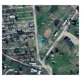
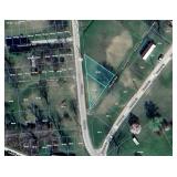
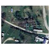
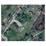
16 Properties Selling to the Highest BidderAcreage, Houses, Rail Trail Properties, Potential
Listing ID#: 844820

| Sale Location |
|---|
|
Pennsboro, WV 26415 |
| Sale Dates and Times |
|---|
|
Bidding Starts: Saturday Feb 7, 9:00 AM Bidding Ends: Tuesday Mar 10, 7:00 PM |
| Sale Type |
|---|
 Online Auction
VIEW ONLINE CATALOG Online Auction
VIEW ONLINE CATALOG |
| Company Information |
|---|
|
Joe R. Pyle Complete Auction & Realty Service Contact: Alan Heldreth Phone: 3045926000 Email: info@joerpyleauctions.com Website: www.joerpyleauctions.com EstateSale.com ID#: 5968 View company information and listings |
Free Email Notifications
Sign up for the EstateSale.com email notifications and we will let you know about sales in your area! You may set up alerts by area (zip and radius), keywords, and by company. It is FREE and only takes a few seconds to sign up.
| Listing Terms and Conditions |
|---|
|
Please read the special terms and conditions before bidding. Buyer is responsible for all closing costs, including but not limited to deed preparation, closing Deed recording services and escrow, All deed recording fees incurred pursuant to the transfer of title, along with any state and county excise tax on the privilege of transferring realty (document stamps), All outstanding real estate taxes, charges, municipal service fees or other assessments levied or assessed against the Premises (Any currently posted county real estate taxes payable at time of closing will be paid by Purchaser at closing; All other outstanding real estate taxes, charges, municipal service fees or other assessments levied or assessed against the Premises will be paid by the Buyer after the closing); Any additional optional services such as: examination of title, title insurance, surveys, loan documentation. Any such optional services are outside of the scope of services provided by Joe R. Pyle Auctions and Walters Law Office.
Disclaimers by Seller: BUYER BEWARE PROPERTY: Purchaser acknowledges that seller acquired title to the property through tax sale, holds the property for resale, not for investment, and has not operated the property. Said tax sale may still be within the statute of limitations, and may be overturned by potential future lawsuits causing loss of title to the property for any current or future owners. IT IS UNDERSTOOD AND AGREED THAT SELLER HAS NOT AT ANY TIME MADE AND IS NOT NOW MAKING, AND IT SPECIFICALLY DISCLAIMS, ANY WARRANTIES OR REPRESENTATIONS OF ANY KIND OR CHARACTER, EXPRESS OR IMPLIED, WITH RESPECT TO THE PROPERTY, INCLUDING, BUT NOT LIMITED TO, WARRANTIES OR REPRESENTATIONS AS TO (I) MATTERS OF TITLE, (II) ENVIRONMENTAL MATTERS RELATING TO THE PROPERTY OR ANY PORTION THEREOF, INCLUDING, WITHOUT LIMITATION, THE PRESENCE OF HAZARDOUS MATERIALS IN, ON, UNDER OR IN THE VICINITY OF THE PROPERTY, (III) GEOLOGICAL CONDITIONS, INCLUDING, WITHOUT LIMITATION, SUBSIDENCE, SUBSURFACE CONDITIONS, WATER TABLE, UNDERGROUND WATER RESERVOIRS, LIMITATIONS REGARDING THE WITHDRAWAL OF WATER, AND GEOLOGIC FAULTS AND THE RESULTING DAMAGE OF PAST AND/OR FUTURE FAULTING, (IV) WHETHER, AND TO THE EXTENT TO WHICH THE PROPERTY OR ANY PORTION THEREOF IS AFFECTED BY ANY STREAM (SURFACE OR UNDERGROUND), BODY OF WATER, WETLANDS, FLOOD PRONE AREA, FLOOD PLAIN, FLOODWAY OR SPECIAL FLOOD HAZARD, (V) DRAINAGE, (VI) SOIL CONDITIONS, INCLUDING THE EXISTENCE OF INSTABILITY, PAST SOIL REPAIRS, SOIL ADDITIONS OR CONDITIONS OF SOIL FILL, OR SUSCEPTIBILITY TO LANDSLIDES, OR THE SUFFICIENCY OF ANY UNDERSHORING, (VII) THE PRESENCE OF ENDANGERED SPECIES OR ANY ENVIRONMENTALLY SENSITIVE OR PROTECTED AREAS, (VIII) ZONING OR BUILDING ENTITLEMENTS TO WHICH THE PROPERTY OR ANY PORTION THEREOF MAY BE SUBJECT, (IX) THE AVAILABILITY OF ANY UTILITIES TO THE PROPERTY OR ANY PORTION THEREOF INCLUDING, WITHOUT LIMITATION, WATER, SEWAGE, GAS AND ELECTRIC, (X) USAGES OF ADJOINING PROPERTY, (XI) ACCESS TO THE PROPERTY OR ANY PORTION THEREOF, (XII) THE VALUE, COMPLIANCE WITH THE PLANS AND SPECIFICATIONS, SIZE, LOCATION, AGE, USE, DESIGN, QUALITY, DESCRIPTION, SUITABILITY, STRUCTURAL INTEGRITY, OPERATION, TITLE TO, OR PHYSICAL OR FINANCIAL CONDITION OF THE PROPERTY OR ANY PORTION THEREOF, OR ANY INCOME, EXPENSES, CHARGES, LIENS, ENCUMBRANCES, RIGHTS OR CLAIMS ON OR AFFECTING OR PERTAINING TO THE PROPERTY OR ANY PART THEREOF, (XIII) THE CONDITION OR USE OF THE PROPERTY OR COMPLIANCE OF THE PROPERTY WITH ANY DECLARATIONS OR COVENANTS OF RECORD OR ANY PAST, PRESENT OR FUTURE FEDERAL, STATE OR LOCAL ORDINANCES, RULES, REGULATIONS OR LAWS, BUILDING, FIRE OR ZONING ORDINANCES, CODES OR OTHER SIMILAR LAWS, (XIV) THE EXISTENCE OR NON EXISTENCE OF UNDERGROUND STORAGE TANKS, SURFACE IMPOUNDMENTS, OR LANDFILLS, (XV) THE MERCHANTABILITY OF THE PROPERTY OR FITNESS OF THE PROPERTY FOR ANY PARTICULAR PURPOSE, (XVI) THE TRUTH, ACCURACY OR COMPLETENESS OF THE PROPERTY DOCUMENTS, (XVII) TAX CONSEQUENCES, OR (XVIII) ANY OTHER MATTER OR THING WITH RESPECT TO THE PROPERTY. Sale "As Is, Where Is." PURCHASER ACKNOWLEDGES AND AGREES THAT UPON CLOSING, SELLER SHALL SELL AND CONVEY TO PURCHASER AND PURCHASER SHALL ACCEPT THE PROPERTY "AS IS, WHERE IS, WITH ALL FAULTS," PURCHASER HAS NOT RELIED AND WILL NOT RELY ON, AND SELLER HAS NOT MADE AND IS NOT LIABLE FOR OR BOUND BY, ANY EXPRESS OR IMPLIED WARRANTIES, GUARANTEES, STATEMENTS, REPRESENTATIONS OR INFORMATION PERTAINING TO THE PROPERTY OR RELATING THERETO MADE OR FURNISHED BY SELLER OR ANY REAL ESTATE BROKER, AGENT OR THIRD PARTY REPRESENTING OR PURPORTING TO REPRESENT SELLER, TO WHOMEVER MADE OR GIVEN, DIRECTLY OR INDIRECTLY, ORALLY OR IN WRITING. PURCHASER REPRESENTS THAT IT IS A KNOWLEDGEABLE, EXPERIENCED AND SOPHISTICATED PURCHASER OF REAL ESTATE AND THAT, EXCEPT AS EXPRESSLY SET FORTH IN THIS AGREEMENT, IT IS RELYING SOLELY ON ITS OWN EXPERTISE AND THAT OF PURCHASER'S CONSULTANTS IN PURCHASING THE PROPERTY AND SHALL MAKE AN INDEPENDENT VERIFICATION OF THE ACCURACY OF ANY DOCUMENTS AND INFORMATION PROVIDED BY SELLER. PURCHASER WILL CONDUCT SUCH INSPECTIONS AND INVESTIGATIONS OF THE PROPERTY AS PURCHASER DEEMS NECESSARY, INCLUDING, BUT NOT LIMITED TO, THE PHYSICAL AND ENVIRONMENTAL CONDITIONS THEREOF, AND SHALL RELY UPON SAME. PURCHASER ACKNOWLEDGES THAT SELLER HAS AFFORDED PURCHASER A FULL OPPORTUNITY TO CONDUCT SUCH INVESTIGATIONS OF THE PROPERTY AS PURCHASER DEEMED NECESSARY TO SATISFY ITSELF AS TO THE CONDITION OF THE PROPERTY AND THE EXISTENCE OR NON EXISTENCE OR CURATIVE ACTION TO BE TAKEN WITH RESPECT TO ANY HAZARDOUS MATERIALS ON OR DISCHARGED FROM THE PROPERTY, AND WILL RELY SOLELY UPON SAME AND NOT UPON ANY INFORMATION PROVIDED BY OR ON BEHALF OF SELLER OR ITS AGENTS OR EMPLOYEES WITH RESPECT THERETO, OTHER THAN SUCH REPRESENTATIONS, WARRANTIES AND COVENANTS OF SELLER AS ARE EXPRESSLY SET FORTH IN THIS AGREEMENT. UPON CLOSING, PURCHASER SHALL ASSUME THE RISK THAT ADVERSE MATTERS, INCLUDING, BUT NOT LIMITED TO, ADVERSE PHYSICAL OR CONSTRUCTION DEFECTS OR ADVERSE ENVIRONMENTAL, HEALTH OR SAFETY CONDITIONS, MAY NOT HAVE BEEN REVEALED BY PURCHASER'S INSPECTIONS AND INVESTIGATIONS. ADDITIONAL TERMS: 1. DELIVERY OF DEED AND POSSESSION: This sale shall be closed by April 30th, 2026 at the offices of Walters Law Office, at which time Seller shall deliver to Purchaser a good and sufficient Quit Claim Deed duly executed and acknowledged, conveying the Premises to Purchaser. Seller is conveying surface rights only with no oil, gas, coal, mineral, or other subsurface interests conveyed. TIME IS OF THE ESSENCE, AND THE TIME OF CLOSING SHALL BE STRICTLY CONSTRUED AND ENFORCED. 2. ADJUSTMENTS/PAYMENT OF CLOSING COSTS: Seller agrees to pay for deed preparation. Purchaser agrees to pay for: Deed recording services and escrow, All deed recording fees incurred pursuant to the transfer of title, along with any state and county excise tax on the privilege of transferring realty (document stamps), All outstanding real estate taxes, charges, municipal service fees or other assessments levied or assessed against the Premises (Any currently posted county real estate taxes payable at time of closing will be paid by Purchaser at closing; All other outstanding real estate taxes, charges, municipal service fees or other assessments levied or assessed against the Premises will be paid by the Buyer after the closing); Any additional optional/outside services such as: examination of title, title insurance, surveys, and loan documentation. Any such optional/services may be procured by Buyer outside of this transaction and prior to closing. 3. CONDITION OF PREMISES: Purchaser accepts the Premises and the improvements thereon in their present physical condition, AS IS, WHERE IS, WITH ALL FAULTS. Seller shall not be liable for any representations or warranties respecting the physical condition, size, or characteristics of the Premises, and unless provided for in this Agreement, Seller is not bound to make any changes, add any improvements, or repair any defects in the Premises. The Premises shall be delivered to the Purchaser in substantially as good a condition as it was on the date of entering into this Agreement, except for usual wear, tear, and loss. 4. RISK OF LOSS: The risk of loss or damage to the Premises shall be borne by the Purchaser from and after the bid strikedown at the time of sale. The Seller will not deliver possession of the Premises to the Purchaser, who shall be solely responsible for obtaining possession of the Premises. Further, the Seller shall be under no duty to cause any existing tenant or person occupying the Premises to vacate said property. 10% nonrefundable down payment made day of auction with balance due at closing. No financing contingencies will be entered into the contract. Any required inspections must be completed prior to bidding. Property is being sold as is, where is with no warranty written or implied. Announcements sale day take precedence over all advertisements published. 10% Buyers Premium will be added to determine final contract price. Name of purchaser on contract must be the name of the winning bidder or an entity which the winning bidder legally represents. No exceptions. AGENCY DISCLOSURE: Joe R. Pyle Auction and Realty Service is acting as Auctioneer/Agent and is an agent for the seller only. DISCLAIMER: All information regarding the description of this property is derived from sources deemed reliable but not warranted. Information is believed to be correct to the best of auctioneer/agent’s knowledge but is subject to inspection and verification by all parties relying on it. Sellers, their representatives and auctioneer/agent shall not be liable for inaccuracies, errors, or omissions. Any references to acreage, unless otherwise noted, are derived from public record and are not warranted. Buyers are responsible for conducting their own research prior to bidding. BUYER/BROKER INFORMATION: Commission will be paid to any properly licensed buyer's broker who registers a successful buyer according to the Broker Participation Guidelines. Broker registration forms are available on our website or from the company office. Broker must be registered 24 hours prior to Auction. Brokers/Agents are not entitled to a commission if they are the purchaser. We don't just list your property - WE SELL IT! JOE R. PYLE COMPLETE AUCTION & REALTY SERVICE Joe R. Pyle, Broker (888) 875-1599 5546 Benedum Drive Shinnston West Virginia 26431 www.joerpyleauctions.com Joe R Pyle WV212 Charlotte Pyle WV2174 Alan Heldreth WV2224 Jordan Kiger WV2246 Bob Stewart, Jr WV825 Bob Stewart, III WV1292 Todd Short WV1649 Tia Wolski WV2351 Ethan Moore WV2354 Taylor Ramsey WV2352 Nick Dawkins WV2410 Bud Shingleton WV1956 Colton McCown WV2463 Garrett Wilkerson WV2541A Thomas Heldreth WV2520A John Powell WV2481A Taylor Self WV2521A Kevin Zakariasen WV2482A Brooke Patterson WV2536A Carter Walker WV2542A |
| Listing Information |
|---|
|
Absolute Online Real Estate Auction
Bidding begins closing Tuesday, March 10th at 7:00PM
Doddridge, Wetzel, Ritchie, and Wirt Counties
Acreage, Houses, Rail Trail Properties, Potential Building Locations
SELLING TO THE HIGHEST BIDDERS
DODDRIDGE COUNTY
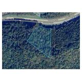
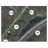
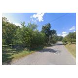
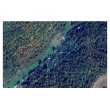
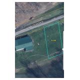
Subject #1: 9.05 +/- Acres Near North Bend Rail Trail
9.05 +/- Acres (as assessed)
BUYER BEWARE – ACCESS UNKNOWN
Approximate GPS Coordinates (39.282411, -80.664661)
Near Bend Rail Trail Tunnel #4 & North Bend Rail Trail Tunnel #3
Doddridge County, Grant District (03), Map 20, Parcel 12.2
Legal Description: BUCKEYE 9.05 AC
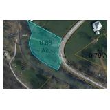
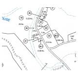
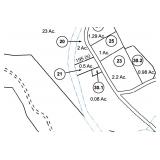
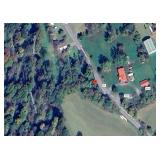
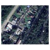
Subject #3: 0.88 +/- Acres on Meathouse Fork Rd New Milton, WV
0.88 +/- Acres (as assessed)
Along Meathouse Fork
Closest Physical Address 1635 Meathouse Fork Rd New Milton, WV
Surrounding Properties with Well, Septic
Doddridge County, New Milton District (06), Map 8, Parcel 41.2
Legal Description: 0.876 AC MEATHOUSE FORK
Subject #4: 0.05 +/- Acres on Meathouse Fork Rd New Milton, WV
0.05 +/- Acres (as assessed)
Closest Physical Address 977 Meathouse Fork Rd New Milton, WV
Doddridge County, New Milton District (06), Map 8, Parcel 28.1
Legal Description: .05 AC NEW MILTON
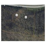
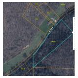
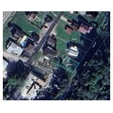
Subject #5: 0.58 +/- Acres on Meathouse Fork Rd New Milton, WV
0.58 +/- Acres (as assessed)
Closest Physical Address 1164 Meathouse Fork Rd New Milton, WV
Property to the left of above address
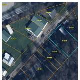
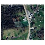
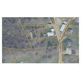
Please note the mapping does not match property
Refer to Tax Map Photo & Google Map Aerial
Per the seller there is an old trailer that has been burnt down on property
Doddridge County, New Milton District (06), Map 8, Parcel 30.1
Legal Description: NEW MILTON LOT 50 X 70 .08 AC
Doddridge County, New Milton District (06), Map 8, Parcel 21
Legal Description: NEW MILTON .5 AC
WETZEL COUNTY
Subject #6: 3,56 +/- Acres on Big Run Rd Burton, WV
3.56 +/- Acres (as assessed)
Closest Physical Address 1459 Big Run Rd Burton, WV
Wetzel County, Grant District (04), Map 8, Parcel 13.1
Legal Description: 3.56 AC BIG RUN
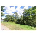
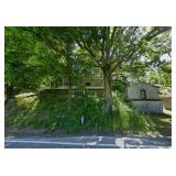
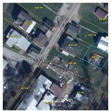
Subject #7: 149 Pike St New Martinsville, WV
0.16 +/- Acres (as assessed)
4 Beds, 1 Bath, 980 +/- Sqft
Public Utilities
Fixer Upper House
Wetzel County, New Martinsville Corp (09), Map 22, Parcel 56
Legal Description: PT 6-A KAPPEL ST 70 X 100
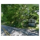
Subject #8: 8698 Hornet Hwy Littleton, WV
1.55 +/- Acres (as assessed)
Fixer Upper House
1,160 +/- Sqft, 3 Bed, 1 Bath
Four Total Rooms
Detached Garage
Wetzel County, Clay District (03), Map 9, Parcel 69
Legal Description: ALL OF BL 3 E V ADD LTN
Subject #9: 256 Browns Run Rd Littleton, WV
0.99 +/- Acres (as assessed)
3 Bed, 2 Bath, 880 +/- Sqft
Six Total Rooms
Well Water, Septic
Wetzel County, Clay District (03), Map 4, Parcel 62
Legal Description: .99 AC BROWNS RUN
Subject #10: 0.12 +/- Acres on Low Gap Run Rd Littleton, WV
0.12 +/- Acres (as assessed)
Along Pennsylvania Fork Fish Creek
Closest Physical Address 395 Low Gap Run Rd Littleton, WV
Surrounding Properties with Well, Septic
Wetzel County, Clay District (03), Map 1, Parcel 15
Legal Description: .12 AC FISH CREEK
Subject #11: 0.05 +/ -on Pike St New Martinsville, WV
0.052 +/- Acres (as assessed)
Property Sits Behind 346 Pike St New Martinsville, WV
Public Utilities Available
Wetzel County, New Martinsville Corp (09), Map 21, Parcel 119.1
Legal Description: .052 AC LOT CAROL LANE 41.78X56.01X42X52.52
RITCHIE COUNTY
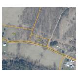
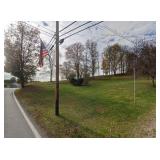
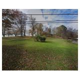
Subject #12: 1 +/- Acre on Marsh Run Pennsboro, WV
1.00 +/- Acres (as assessed)
Closest Physical Address 300 Marsh Run Pennsboro, WV
Surrounding properties with Septic, Well
Ritchie County, Clay District (03), Map 9, Parcel 19.1
Legal Description: SUR 1 AC NFHR
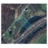
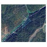
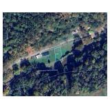
Subject #13: 0.64 +/- Acres along North Bend Rail Trail Harrisville, WV
0.64 +/- Acres (as assessed)
Near Camp Hope (First Apostolic Church Campground)
Closest Physical Address 515 Waystation Rd Harrisville, WV 26362
Access Only by Rail Trail – No other access known
Ritchie County, Grant District (05), Map 18, Parcel 14.1
Legal Description: HUSHERS RUN STATE 1958 140X450X400 FEE
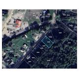
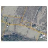
Subject #14: 0.71 +/- Acres on Pullman Rd Pennsboro, WV
0.71 +/- Acres (as assessed)
Closest Physical Address 109 Pullman Rd Pennsboro, WV
Surrounding Properties with Well, Septic
Potential Building Location
PLEASE NOTE: Only 3/4 Interest in the Property will be conveyed.
Ritchie County, Pennsboro Corp (08), Map 14, Parcel 6
Legal Description: NEAR PENNSBORO 100X297X100X318 LOT 14 FEE B 3/4 FEE
WIRT COUNTY
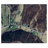
Subject #15: 0.14 +/- Acres on Bailey Rd Elizabeth, WV
0.14 +/- Acres (as assessed)
Two Parcels Totaling 0.14 +/- Acres
Near the Little Kanawha River
Wirt County, Newark District (05), Map 2B, Parcel 39
Legal Description: SEC H LT B-2 HUGHES RIVER 52.88X64.58X40
Wirt County, Newark District (05), Map 2B, Parcel 40
Legal Description: SEC H LT B-1 HUGHES RIVER
Subject #16: 0.25 +/- Acres on Kanawha Way Elizabeth, WV
0.25 +/- Acres (as assessed)
Near the Little Kanawha River
Wirt County, Newark District (05), Map 2B, Parcel 44
Legal Description: 1 LOT SECT J B-7 10,155 SQ FT
Subject #17: 0.13 +/- Acres off Marshall St Elizabeth, WV
0.13 +/- Acres (as assessed)
Wirt County, Newark District (05), Map 2E, Parcel 188
Legal Description: SEC L BLK A LOT 6 SPRING VALLEY 60 X 100
We don't just list your property - WE SELL IT!
JOE R. PYLE COMPLETE AUCTION & REALTY SERVICE
Joe R. Pyle, Broker
(888) 875-1599
5546 Benedum Drive Shinnston West Virginia 26431
www.joerpyleauctions.com
Charlotte Pyle WV2174
Alan Heldreth WV2224
Jordan Kiger WV2246
Bob Stewart, Jr WV825
Bob Stewart, III WV1292
Todd Short WV1649
Tia Wolski WV2351
Taylor Ramsey WV2352
Nick Dawkins WV2410
Bud Shingleton WV1956
Colton McCown WV2463
Garrett Wilkerson WV2541A
Thomas Heldreth WV2520A
John Powell WV2481A
Taylor Self WV2521A
Kevin Zakariasen WV2482A
Brooke Patterson WV2536A
Carter Walker WV2542A
|
|
Photo Gallery
|
|||||
|---|---|---|---|---|---|
|
|||||


Share This Listing
Other Sales by
This Company
Jul 6Marmet, WV
Jul 6
Salem, WV
Jul 6
Shinnston, WV
Jul 7
Moundsville, WV
Jul 7
Elkview, WV
View all listings
